“The rate at which Storm Ciarán’s pressure dropped was exceptional…” Meteorologists Suzanne Gray and Ambrogio Volonté explain why the winds from Storm Ciarán in the UK and France were so strong
Storm Ciarán made landfall in southern regions of the UK during the evening of 1 November 2023. The UK’s Met Office issued amber weather warnings for 2 November in specific areas in the south of the UK, cautioning about high winds. This amber alert represents the second-highest level in the Met Office’s three-tier system.
Yellow warnings were also in place for both wind and rain, extending over a broader area and timeframe.
Ciarán unleashed extremely strong and destructive winds in some areas. Gusts of up to 102 mph (162kmh) were recorded in Jersey, and there have been reports of an 128 mph wind gust (205kmh) in Brittany on France’s north-west coast. For comparison, the record wind gust in England stands at 122 mph (196kmh), set in 2022.
But why were Storm Ciarán’s winds so strong? The explanation lies in the fact that Ciarán was not your typical extratropical cyclone (or windstorm); it was an explosively developing one.
An explosive cyclone
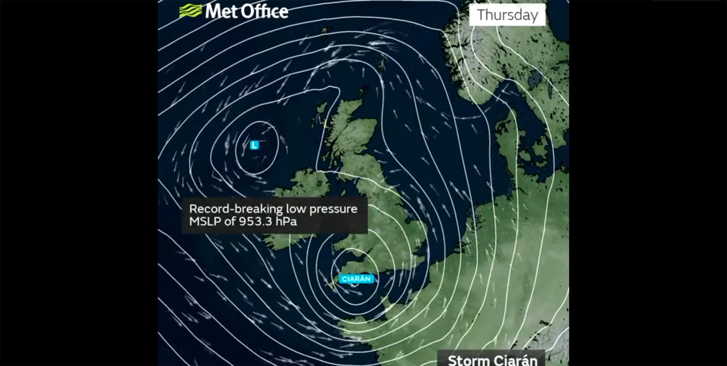
One notable characteristic of Storm Ciarán was the extreme depth of its low-pressure centre. The UK Met Office announced that the central surface pressure, when adjusted to the mean sea level value, dropped to 953.3 millibars (mb) – a new record for England and Wales in the month of November.
⚠️ #StormCiarán has set a new record for the lowest mean sea level pressure recorded in England and Wales in November, with a value of 953.3 hPa (mb) in Plymouth and 958.5 hPa (mb) in St Athan
◾ The previous record in England was 959.7 hPa (mb), set in 1916
◾ The previous… pic.twitter.com/zruckdYR2K
— Met Office (@metoffice) November 2, 2023
The rate at which Ciarán’s pressure dropped was also exceptional. In fact, it far exceeded the threshold of approximately 24 mb in 24 hours (with a slight adjustment based on latitude) required to classify a storm as an explosively deepening cyclone “bomb”.
This rapid intensification occurred as Ciarán, initially fuelled by the ascent and condensation of air over warm waters, found itself positioned beneath the front-left side of a particularly intense jet stream. The jet stream, characterised by high winds approximately six miles (10km) above the Earth’s surface, reached speeds of up to 200 mph (321kmh) on November 1, making it an especially favourable environment for a storm to intensify in.
Why is this important?
One of the primary factors influencing the intensity of surface winds in a storm like Ciarán is the rate of change in surface pressure. On weather charts, you’ll often encounter lines of constant surface pressure, known as isobars. When isobars are closely spaced, they indicate the presence of strong winds.
To illustrate this concept, picture two columns of water, one deeper than the other. If these columns are connected near their bottom ends, water will naturally flow from the deeper column to the shallower one, resulting in a stronger flow when there’s a significant difference in water depth. Similarly, air in our atmosphere tends to move from areas of higher pressure to lower pressure. The greater the difference in pressure, the stronger the associated winds.
Because the Earth is rotating, these winds turn towards the right and generally follow the direction of the isobars rather than being directed towards the low pressure. Bomb cyclones obtain deep low-pressure centres, and the isobars are most tightly packed in the south-west quadrant of the storm, resulting in the strongest “gradient” winds in that region.
In Ciarán’s case, this arc-shaped north-eastward travelling region covered Brittany, the Channel Islands, the far south-west of England and eventually the country’s far south-east.

© [2023] European Centre for Medium-Range Weather Forecasts (ECMWF), CC BY-NC-SA
Often, these storms also move rapidly. Fast travel speed further contributes to the strength of the surface winds. This was the case for Ciarán, which crossed the North Atlantic in just a couple of days.
Did Ciarán have a sting jet?
During some intense windstorms, there can be an additional airstream known as the “sting jet”. Sting jets originate from specific cloud regions within the cyclone and can generate brief (lasting a few hours) and relatively small (60 miles or 100km across) areas of extremely strong winds, which are accompanied by very intense gusts should they reach the ground.
Storms containing sting jets have a distinctive structure, often characterised by rapidly deepening clouds. The evolution of Storm Ciarán was consistent with that structure.
Satellite images before the storm hit revealed narrow bands at the tip of the cloud hooking round the storm centre, the region from which the sting jet descends. However, detailed analysis will be required after the event to confirm whether sting jets were present.
Sting jets do have the potential to worsen the damage caused by storms. But it’s important to note that Ciarán was forecast to unleash strong winds even in the absence of a sting jet.
As a point of reference, Storm Eunice, which gained notoriety in February 2022 for prompting the first ever Met Office red warning for wind in southern England, setting England’s current wind gust record, and damaging the roof of London’s O2 arena, featured a sting jet.
However, by the time the storm arrived London, it had reached a mature stage. And our own research suggests that the damaging winds were the result of a combination of several different airstreams, including a sting jet.
In explosively developing cyclones such as Storm Ciarán, damaging winds can be caused by a number of different airstreams that include, but are not limited to, sting jets.
This article was originally published by The Conversation and is by Suzanne Gray, University of Reading and Ambrogio Volonté, University of Reading