Marcus King tries out this online flight planner and review tool
When the popular free-flight planning tool XCPlanner lost the ability to display airspace recently, thanks to changes at Google, pilots started to look for alternatives. Naviter’s SeeYou Cloud is such an alternative – and it offers a lot more than just planning software. Based on the company’s SeeYou software that runs as an application on Windows PCs, the cloud version allows anyone to use it over the web.
A trial subscription allows you to freely use the planner and analyse your latest flight. But to use all the features you will need a subscription – at €49 a year. If you buy a Naviter instrument it will include a discount code for the service, making the first year just €25. If you want weather information integrated you will also have to pay for this separately through a subscription to TopMeteo: service for one country is around €80 for a year or SkySight.io, again €80 per year.
Once you log in through the website you will be presented with the dashboard. If you have a weather subscription it will display a three-day weather forecast with wind at different heights, plus thermal height and cloudbase. Below that you will see the details of your latest flight, then a list of all the other flights you have loaded into the system.
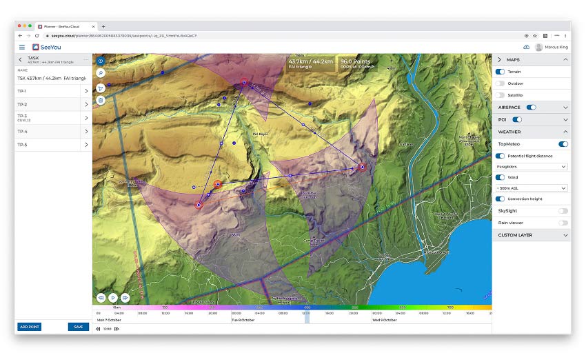
Heading to the planning page you find a map display with optional weather information below. You can create task turnpoints here by clicking on the map and then dragging around. The system shows you the distance and the points you will get for your flight, if it is a triangle or out-and-return etc. When you do create a triangle route there is a display of the FAI zones so you can optimise your route to be an FAI triangle (picture above).
Airspace information can be turned on and is displayed clearly. Wind and convection height info can be overlaid, and you can set the time over the next three days you want this information for. Clicking on a spot gives access to detailed airspace and weather information for that location. One useful addition to this would be a Skyways overlay showing tracklogs from other people’s flights.
The map display is nice and clear: you have the choice of SeeYou maps; outdoor maps that are an uncluttered vector format; and satellite view. The SeeYou maps are particularly clear, with a good representation of the terrain. For Oudie and Hyper owners these are reason enough to subscribe to the service as you can then transfer them to your machine, giving you a much clearer display than the standard maps on those instruments.
Once the task has been created you can download it as a CUP file that can then be transferred directly to your instrument. It would be nice to see other formats available such as GPX so the software works with more instruments.
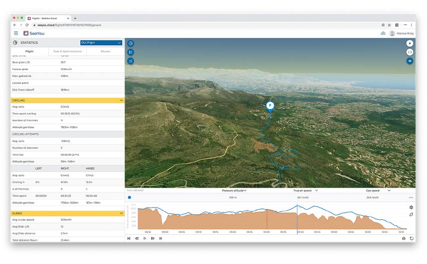
SeeYou Cloud can also act as your logbook by uploading IGC files. Once the flights are in the system you can look at them in detail and play them back in both 2D and 3D (below). You’ll need a fast Internet connection for the latter. You will also find a detailed set of statistics for each flight, so you can analyse your performance. There are detailed figures for thermalling and gliding with the flights broken into sections and compared with any active task. Lots for those who love figures to delve into.
All in all it’s an extensive system that Naviter say they will continue to add functionality to. It obviously integrates particularly well with Naviter instruments, but is also a useful tool for those that use alternatives.
Published in Cross Country Issue 205 (Nov 2019)