Cross Country’s meteorologist Honza Rejmanek gives a masterclass on how to read downslope winds – and whether it’s safe to make those end of the day sled rides.
You reckon you have just enough time for an after-work hike-and-fly from a nearby mountain. Winds are light so the chances of it being blown out are nil.
Due to unforeseen delays though you start hiking later than planned. You know you’ll get to the launch before sunset but it will be an extended sled ride at best.
The lower launch is about two-thirds of the way up and there are several spots to launch near the crest. During your hike the lower launch falls into shade. By the time you arrive it is starting to blow down in occasional light cycles broken by periodic lulls.
You decide to quickly set up and forward launch. However, by the time you are ready the occasional down cycles have turned to a light, steady downslope flow. With trees out in front this spot becomes unlaunchable. Checking your watch you calculate that you could get to the upper launch at sunset but that is a gamble that could result in a long hike down in the dark.
What is a katabatic wind?
To make an educated decision for this scenario it is worth taking a closer look at the characteristics of katabatic flow. Sometimes all downslope flow is called katabatic. This is somewhat misleading, because winds like the Foehn, the Santa Ana, the Chinook, the Bora do blow downslope but they are synoptically driven, they tend to be quite deep, and they can last for days.
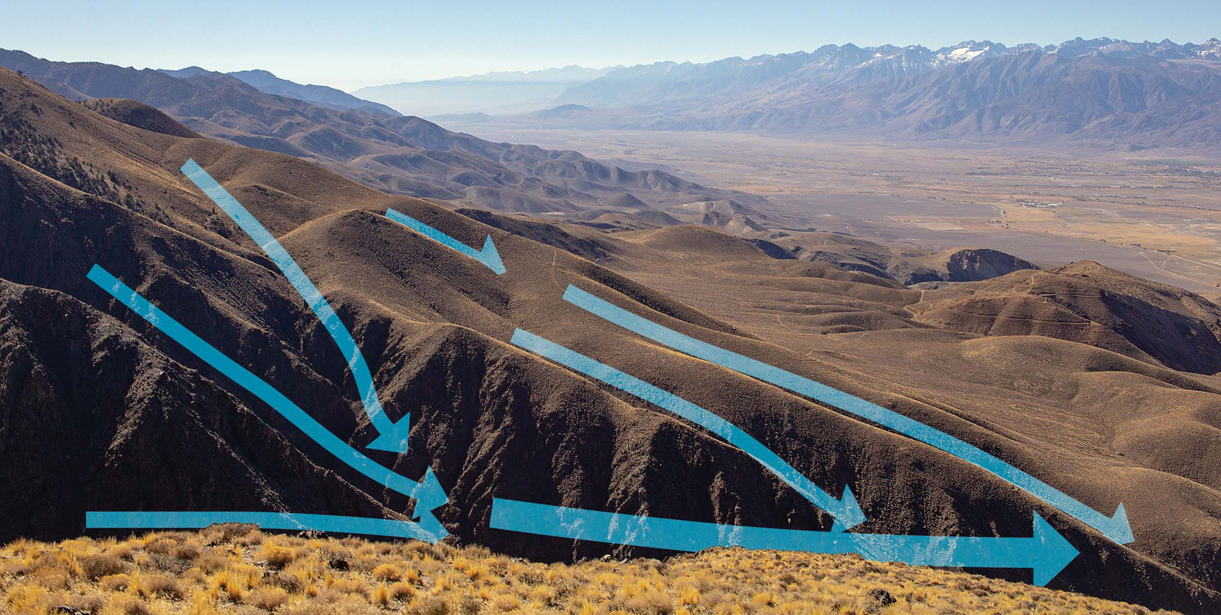
For the sake of our discussion we will consider localised katabatic winds – also known as drainage winds, gravity flows, or gravity currents. These downslope flows follow a diurnal schedule and are most pronounced on clear evenings, nights, and early mornings when the synoptic wind is light. They tend to be fairly shallow – especially true in their early onset and higher up the slope.
Katabatic winds are the result of radiative cooling of the air in contact with a sloping surface. The air gets denser and heavier as it cools. On a slope this heavier air begins to feel the tug of gravity and begins to flow downslope. The flow picks up speed along the way.
Early in its onset a katabatic flow can strip itself off the slope because it is quite thin. It can then take a few minutes to rebuild the cold layer and set off another pulse. This is almost like thermals, but in reverse. As the cooling increases these initial down cycles give way to almost uninterrupted downslope flow.
Gullies and the valley floor
With these concepts in mind you decide to quickly pack up your glider and hike up to the top launch at the crest. Despite feeling light downslope flow in your face as you ascend, you notice that it is slightly stronger in the gullies than on the spines. The reason for this is that katabatic wind behaves much like water would on a sloped surface, it tends to follow drainages. Hence the term drainage flow.
As you near the last 100 vertical metres before the crest you begin to feel encouraging signs. It feels that you have hiked out of the drainage flow. As your trail takes you over spines and gullies you notice that the air is now calm on the spines. You make a final push for the launch near the crest. In the final 50m you are rewarded by very light upslope flow. The crest is still feeling the light synoptic wind. You get to fly down!
In the valley there is a light down-valley flow in the landing zone and you notice a pronounced temperature drop as you are on final approach. The valley inversion is just starting to form. It will grow in depth through the night. Given the right topography some valleys form cold pools with localised pockets of extra cool still air.
Topography and ground cover
How quickly a katabatic wind will set in after a face has fallen into shade depends on several factors. If the synoptic wind is light then it will not be very effective at mixing out the cold dense layer forming on the shaded slope. Hence, it will be easier for the katabatic wind to organise.
A clear, cloudless sky allows for maximum radiative cooling. At higher altitudes there is less air above you to attenuate cooling to space so the cooling rate of the surface will be faster. If the air mass is dry with very little water vapour then it is also easier for the surface to radiatively cool.
The surface properties also play a substantial role. Snow or glaciers are good at cooling the overlying air even during the day. However, once these slopes fall into shade the surface temperature starts to plummet. Katabatic winds set in very quickly. If the slope is steep and the snowfield is vast then it is not uncommon to have katabatic winds reach 10m/s within an hour of the slope falling into the shade. This is especially true if you are in drainage where these downslope flows are converging.
Wet or damp slopes also cool very quickly once they fall in the shade. These vegetated slopes will initially develop lighter katabatic winds in the order of 3-4m/s.
Rocky slopes that took a long time to heat will be the last to turn katabatic after falling in the shade. Big rock walls might take several hours to become cooler than the surrounding air after they have fallen in the shade.
As soaring pilots we often strive to develop a mental model of daytime flow which gets quite intricate as thermals turn on. As thermals turn off we want to have a sense of how fast upslope flow can give way to downslope flow. The nice thing is that katabatic flow is actually easier to envision.
This article was published in Cross Country 190 (June 2018)


