’10 years of what I know about the weather’
10 standout lessons from Cross Country's longtime weather columnist
10 April, 2025, by Honza RejmanekHonza Rejmanek writes a regular weather column for Cross Country Magazine. After 10 years and over 70 articles, Honza says, “It felt like a good moment to to summarise 10 chosen weather concepts. This short list is by no means exhaustive, but it might help pilots understand some of the mysteries regarding the invisible medium we choose to bounce around in for fun.”
1. The air does not see the terrain exactly the way we do. There are stagnation zones on the upwind sides of a terrain feature. These are most noticeable when walking on a mountain. You can be on the upwind side of a mountain and feel light wind when it can be blowing way too strong for flying at the same level on the sides of the hill. If it is suspiciously light it is worth a hike to the crosswind side of the mountain to verify that you were not in a stagnation zone.
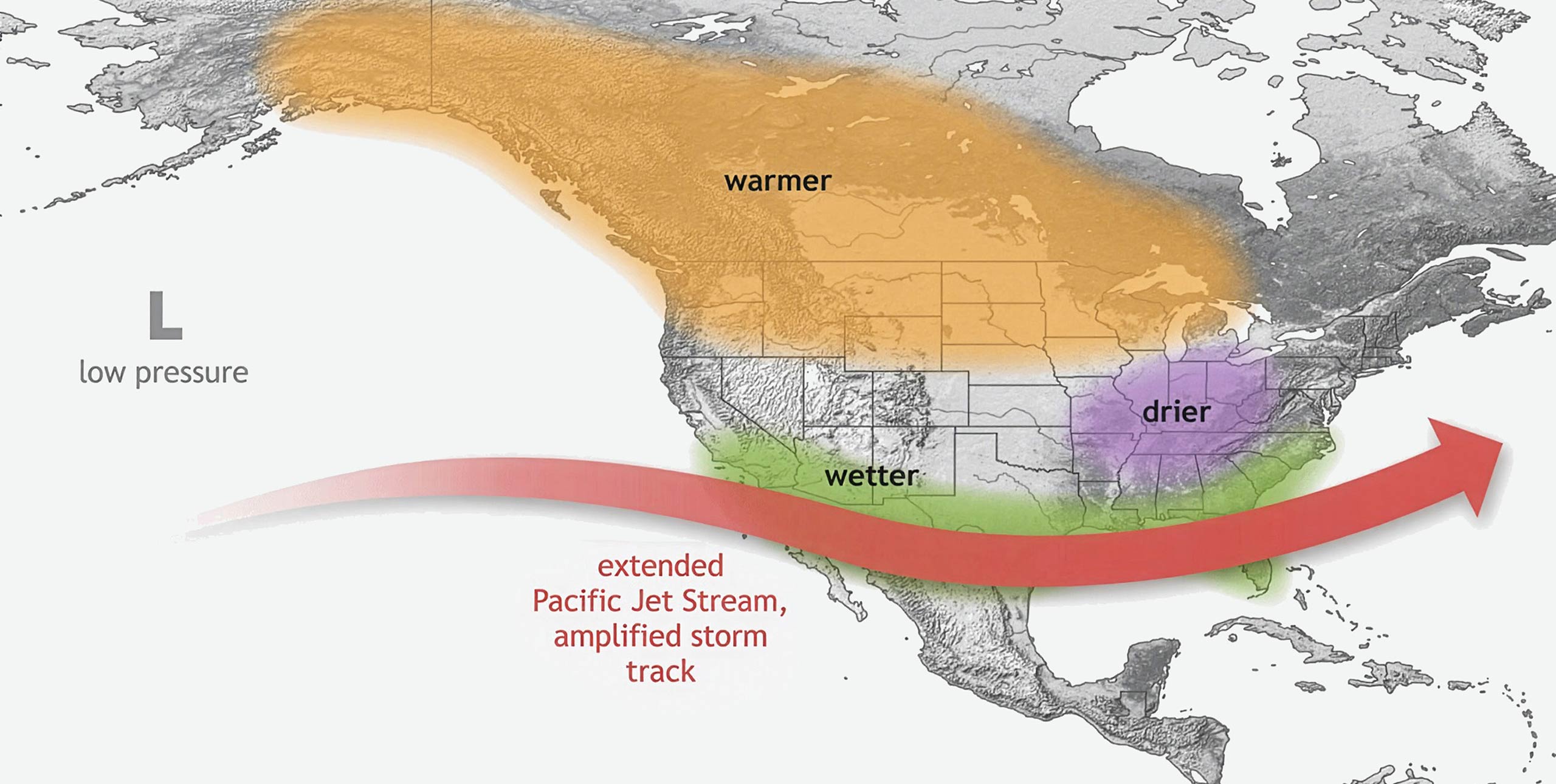
2. At least three scales have to be considered in making sense of the wind we feel. In short, the wind we feel at any location is a sum of synoptic, regional, and local flow. In general, global models only resolve the synoptic wind. Higher resolution models might pick up crude regional features of the flow. Local winds such as venturi, slope flow, ridge-top compression or thermals are not resolved. However local flows superimposed on a marginally strong forecast wind can result in gusts that can exceed comfort.
3. Convection is best thought of as a push-pull situation. Sometimes the ground is shaded and thermals are plentiful. Other times there is not a cloud, the ground is baking and thermals are sparse enough so it’s a challenge to stay up. Convection, hence thermals, is not solely reliant on surface heating but it is also significantly affected by what occurs above the convective boundary layer. Cold air advection above can destabilise the boundary layer just as much, or more, as heating from below. Conversely, warm air moving in aloft stabilises the convective boundary layer and reduces thermal frequency and strength.
4. If a thermal breaks through an inversion then there was not much of an inversion left in that location. Thermals will not break through strong inversions. They will shoot up into them for maybe a hundred or more metres due to momentum but will soon turn to sink as they come to a halt and find themselves negatively buoyant. If a thermal continues to ascend then the inversion or stable layer it passed through was weak, shallow, and almost eroded away.
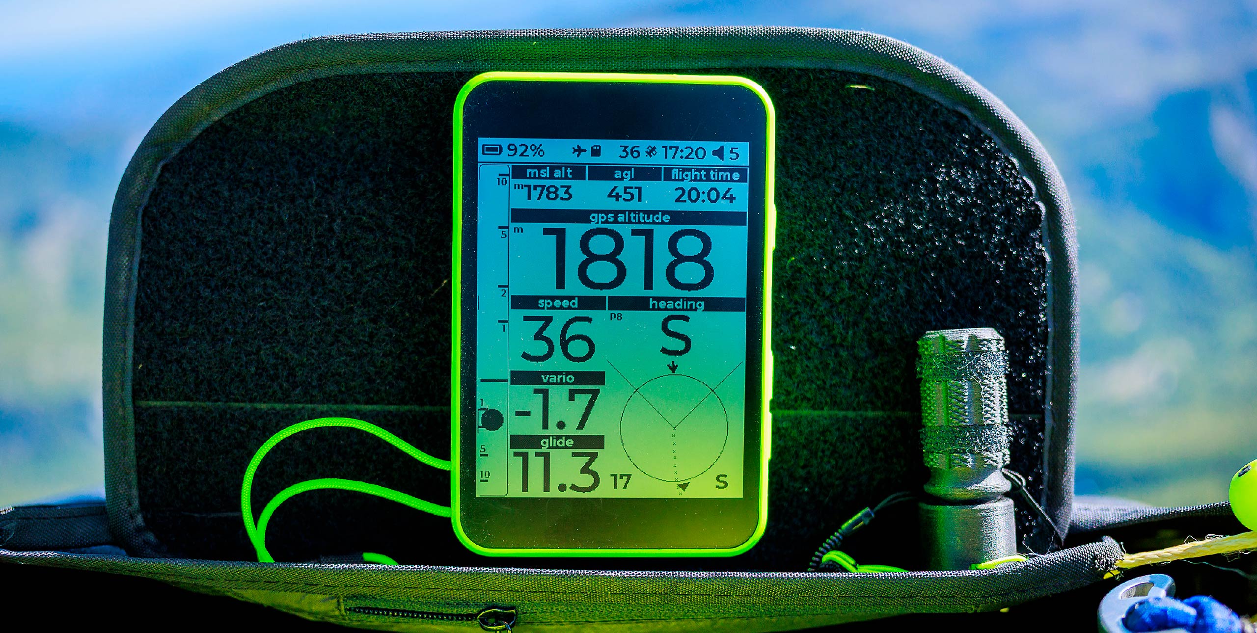
5. It is worth taking time to learn to read a sounding. This is especially true if your flying site is within fairly close proximity to where the weather balloon is launched. Each sounding is unique like a fingerprint. It is worth learning to recognise what a fingerprint of an epic flying day looks like.
6. Creating buoyancy by evaporating water is about twelve times more energetically expensive compared to just heating the air. Air can become buoyant by being heated or by having a lighter gas such as water vapour mixed into it. However the latter comes at a much higher cost energetically. This is why, given the same sun angle, humid places will have much mellower thermals than deserts.
7. Latent heat release drives much of our weather and allows for deep convection. When water condenses it releases a tremendous amount of heat. Sometimes the troposphere is unstable for a convective cloud that is releasing this heat. In such cases the cloud is more buoyant than the air outside the cloud thanks to this latent heat release. The cloud accelerates up. Initially the clouds will be too skinny and mix in too much surrounding air. As they fatten they can grow into full-blown cumulonimbus. This is a transition to deep convection. The entire troposphere starts to boil or convect. Best observed from the LZ, not the air.
8. Clarity of air can make a big difference in how early thermals start, how strong they get, and how late into the evening they last. When the air is laden with smoke or dust then the sun’s rays are attenuated and the ground heats less. This is especially true when the sun is at a lower angle and has to travel through more atmosphere. Additionally, all the fine particulates heat up when exposed to the sun. The surrounding air is heated. This is a stabilising scenario: air heats above and the ground heats less below.
9. Convergence can produce abundant lift in unexpected places. In our initial years of flying we get quite familiar with thermals and ridge lift. In complex topography there is a third and more elusive form of lift called convergence lift. When valley winds are channelled at each other a region of rising air can exist above. In the vertical there is often a slant to the convergence zone. Sometimes these convergence lines set up over a fixed spot and sometimes they migrate.
10. It takes less energy to turn thermals on at high elevation flying sites. The air is less dense at altitude. Therefore with the same surface heating it becomes easier for thermals to turn on. Another way to think about this is that at lower density a finite volume of air has less heat capacity, so it takes less heating to raise the temperature.
Honza Rejmanek writes a regular weather column for Cross Country magazine. An accomplished cross country pilot he competed in the Red Bull X-Alps five times but now enjoys flying father-and-son tandem vol-bivs at home in California and overseas in the European Alps