Meteorologist Honza Rejmanek discusses why springtime can mean strong and feisty flying conditions.
The long winter has stretched into spring. It is now a month past the equinox and it looks like you will finally get a great post frontal day on a Saturday! You get your kit sorted the night before. It is hard to fall asleep that evening. You are looking forward to the end of a long hiatus from thermal flying.
However there is a part of you that feels slightly anxious at the prospect of bouncing around in punchy springtime thermals. You begin to ponder whether springtime thermals are really all that punchy, or is it the fact that our bump tolerance is low this time of year?
Certainly a lack of currency can make a strong thermal feel rougher than it might otherwise, however there are in fact several factors that can lead to surprisingly strong springtime thermals.
The big picture
It is important to realise that from the perspective of incoming solar radiation springtime receives the same amount as summertime but in reverse order. Spring ends and summer starts at the summer solstice when days are at their longest and the sun carves its highest arc through the sky. In the northern hemisphere the sun will carve the same arc across the sky in late-April as it does in mid-August. Many of the steeper south faces will receive perpendicular rays at high noon. Exposed dry surfaces will heat significantly.
What makes springtime unique in the mid-latitudes is that there is still an abundance of cold air in the ice and snow covered polar regions. This lag in heating of the polar air assures that frontal systems are more frequent than in the summer months.
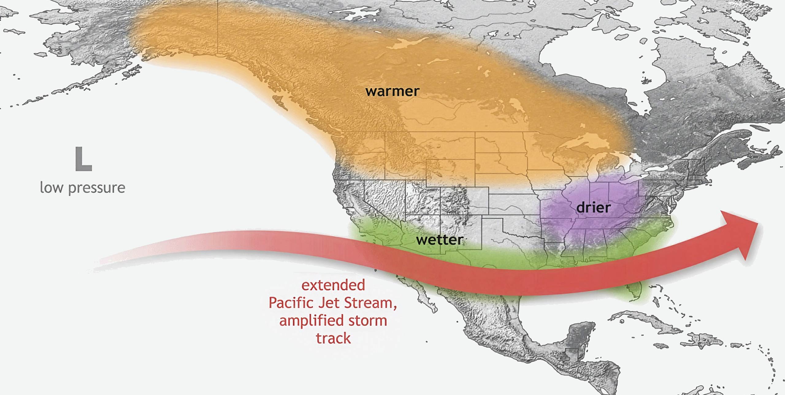
Frontal systems, or mid-latitude cyclones, are depicted by a bullseye of isobars on a surface chart centered on a big L. An extra-tropical, or mid-latitude, cyclone can be thought of as a great mixer that helps alleviate the north-south temperature gradient. Polar air is brought equatorward and subtropical air is brought poleward. In some regions a steady succession of these cyclones leads to prolonged periods of bad weather. When they are spaced further apart we want to keep our eye out for the day or two after a cold front has passed. Post-frontal conditions will often bring air that is cool, dry, and possesses a steep lapse rate.
Clean, clear air
Having freshly arrived from the polar regions the air is clean of aerosols, or dust and smoke particles. This allows the sun’s rays to reach the ground unhindered. In contrast, the summer months can experience long spells under the influence of high pressure allowing aerosols to accumulate in the boundary layer. This has a stabilising effect because some of the sun’s rays are intercepted heating the air from above.
If the visibility is good and the sun feels strong on your face early in the morning then it might be a great flying day. If the dew-point temperature is low compared to the forecast high temperature, then there is a good chance for a high cloudbase. Of course it is important to make sure it is not going to be too windy for your skill level.
[promobox]
XC days in spring
To get a strong thermal we need a fast heating-rate of the air near the surface and a deep layer with a steep lapse-rate through which the thermal can accelerate and get up to speed.
Spring will generally bring fewer flyable days than the summer, but when a flyable day sets up it often allows for great flights and a deep boundary layer. A light wind day after the passage of a cold front can yield a day with a long flying window and high cloud bases and spectacular views.
If the higher mountains are still snow-covered then there are fewer thermals to draw in a strong valley wind than on summer day. Thus crossing of large valleys can be easier in the spring than in the summer. This is why some very long XC flights can be flown in the spring.
Ground cover
Strong heating rates occur when there is a strong temperature contrast between the surface and the air overlying the surface. Drier surfaces are more likely to develop this surface-to-air temperature contrast. Wet or vegetated surfaces do not heat very efficiently because much of the net radiation is spent on evaporating water.
In springtime lower deciduous trees are starting to leaf while those on higher slopes are still in winter mode. More of the sun’s energy can go into heating the surface without the presence of a dense leaf cover.
It is important to remember that a surface can lose heat by conduction, convection, and radiation. In the summer it can be more difficult to maintain a strong temperature contrast between the surface and the overlying warm air. A surface radiates in the longwave. As the surface gets hotter it loses a greater percentage of its heat to space by longwave radiation. Less energy is available for heating the air.
In springtime though it is not uncommon for cold air to continue to blow in aloft while the surface air heats from below. This destabilising scenario is good for thermal production.
As strong as summer
In sum the factors discussed can conspire together on a clear, crisp spring day to produce surprisingly strong thermals, easily as strong as in the summer.
If you have a personal rule of not flying midday thermals in the summer then you will be wise to adhere to this rule in the spring too. This would be particularly prudent if you have not flown in thermals all winter.