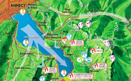
Detail of the new paragliding and hang gliding map of Annecy, France
Download the 2012 paragliding guide to Annecy

The Annecy tourist office has published a new map for paraglider and hang glider pilots.
The illustrated map features all the take off and landing zones, plus information on the valley wind system – and those all important house thermals.
It also comes complete with information on the raptors you might see, what their in-flight behaviour can mean, and where and when to avoid flying through their nesting territory.
The map is available free in Annecy, France, from paragliding schools or the tourist office.
Or you can download it here as a pdf.
• Got news? Send it to us at news@xccontent.local
Subscribe to the world’s favourite hang gliding and paragliding magazine


